Lately I've been working with the Somerville Bicycle Advisory Committee (SBC) to develop a few signed bike routes throughout the city. Ordinarily a City our size shouldn't need signed bike routes. Boston on the other hand is large enough to justify them, and is working on them.
Most of our direct routes require riding on rather busy streets. Often, these routes have lower traffic alternatives, often with better bicycling infrastructure. Except these alternative routes can be more complicated, thus signage would be helpful.
What I'm trying to figure out is what type of signage would work best in Somerville. Here are a few of the goals and constraints that we have:
- Limited street space for large signs or kiosks, more space can sometimes be found at key landmarks, destinations and parks, but not always.
- Limited funding available for signage, so every element of the system must count, and the ability to use existing sign posts and structures would be helpful.
- A multi-lingual society, so the use of symbols is preferred where possible.
- Dual use of signage for pedestrians is a preference if possible.
There are a few methods of developing a route that will impact how the signage functions and appears. We haven't made this decision, so it is important to consider these three different methods.
Method A Route Signage:
Though bike routes often have names, the signage for the route is almost always numbered. The signs are similar to what is used for highways. An examples of bicycle route signage is the Claire Saltonstall Bikeway from Boston to Provincetown, which is Bicycle Route 1 in Massachusetts. Incidentally it is the only numbered bicycle route in Massachusetts. The standard US bicycle route sign is shown below. These signs can be confusing, as they do not include route identification or destination information. Of course our highway signs do not include this information either, however highway maps are ubiquitous and are generally understood by all Americans (even those that do not drive).

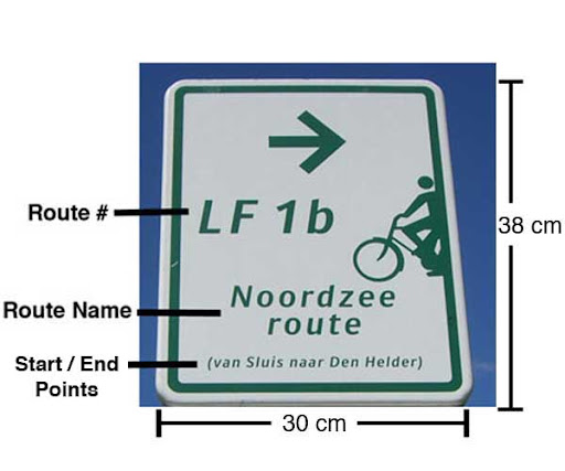
Another example is the Dutch LF Routes managed by the ANWB (the Dutch multi-modal equivalent of the AAA). Similar to the Claire Saltonstall Bikeway, LF routes are long distance bike routes. The signs are similar to the US sign, except they provide additional information, as shown below and described further here. Often these signs include the organization managing the route, typically the ANWB in Holland.
Method B Destination Signage:
Destination signage highlight the destination instead of the route. For motorists, they are typically found accompanying highway route signs, particularly at junctions. Destination signage for bicyclists are most commonly used in urban areas. Most cyclists in urban areas are going somewhere in particular, not traversing a specified route, thus destination signs are more useful. There are of course exceptions, such as the East Coast Greenway. NACTO has a great site describing various bicycle signage systems, primarily focussing on destination signage, but also some route signage. A Berkeley example of a destination sign:

The primary difficulty with destination signage is their size and expense. To accomodate the name of the destination in a legible size, the sign must be large, and thus more expensive than other bicycle wayfinding sign types. In an urban area where destinations are more important, maps less common, and visitors more common, destination signs will always be important. Though it would be nice if they could be limited to junctions and not required at every turn. A secondary concern is that they require both literacy and some understanding of a particular language, which all cyclists are not guaranteed to have.

Another type of destination sign that resolves some of the above concerns is the Czech system of mute blazes. Instead of using the names of the destinations the signs use symbols that represent the destinations. The size of these signs could be significantly smaller than destination name signs, thus easier to fit along the route. Of course, destination name signs would still be necessary at junctions and to help define the meaning of the symbols. In addition it is usually easier & quicker to interpret a pictoral symbol than it is to read a name. It may be easier for cyclists to recognize the symbolic signs while moving.
Method C Nodal Signage:
The third signage method is with nodes. This system originated in rural Belgium to aid bicycle navigation on the many country roads and paths. This system includes a dense network of designated bicycle routes, too many to number and name. Instead they number the intersections or nodes. Each stretch of bicycle route connects two nodes, and the signs direct the cyclist to the next node ahead.
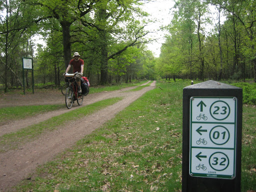
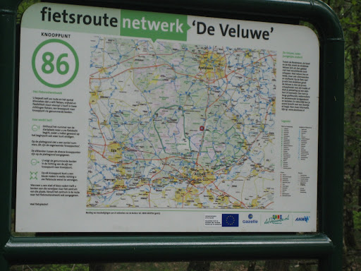
It provides for a very flexible system that can accomodate point to point, loop, short and long rides. This system does require a map to navigate, yet maps are located at most nodes throughout the network.
This system allows for small numerical signs along the routes to provide direction. Yet the routes do not need to be point to point, which the standard route signage requires. It is more difficult to learn since it is not common here, though similar system are often used at cross-country ski and hiking areas.
The most likely candidate for wayfinding signs in Somerville is Destination Signage, if we can develop a more cost effective system that can fit along smaller streets. Maybe an innovative combination with Route or Nodal Signage may work. I welcome your thoughts and ideas.


I think Somerville is best navigated by squares. I believe many people navigate by figuring out which square something is near, and then heading in that direction - that's certainly the way that I organize the landscape in my mind.
ReplyDeleteI'd go with a set of destination signs (like Berkeley's above) which lists the squares in each direction:
Davis 1.5m ->
<- Union .3m
[etc.]
It's pretty language-neutral, though not as much as the icons of the czech system you show above. However, our squares don't really have easily associated icons in many cases, so I'd be worried that many of them would seem forced and ultimately be confusing.
I agree that destination signs would work best for Somerville.
ReplyDeleteLike other signage, it would be nice if this were regulated -- i.e. made uniform -- by the state. It will be very confusing if I need to learn one system for Boston, another for Cambridge, and a third for Somerville.
ReplyDeletep.s. Cambridge has signs that theoretically direct one from Harvard Square to Alewife and/or the Minuteman bike path. I tried to use this to find a new route around Harvard Square (my usual route involves some use of sidewalks, etc.) but the signs disappeared after a while.
Good design for way-finding sign boards.
ReplyDeleteThanks for the post. Wayfinding signages are very useful and many times it is like a companion for travelers. Even for local people who are travelling in vehicles name signage board are very useful.
ReplyDelete